


WEATHER DOT COM
-
Posts
2,616 -
Joined
-
Last visited
Content Type
Gallery
Profiles
Forums
Events
Posts posted by WEATHER DOT COM
-
-
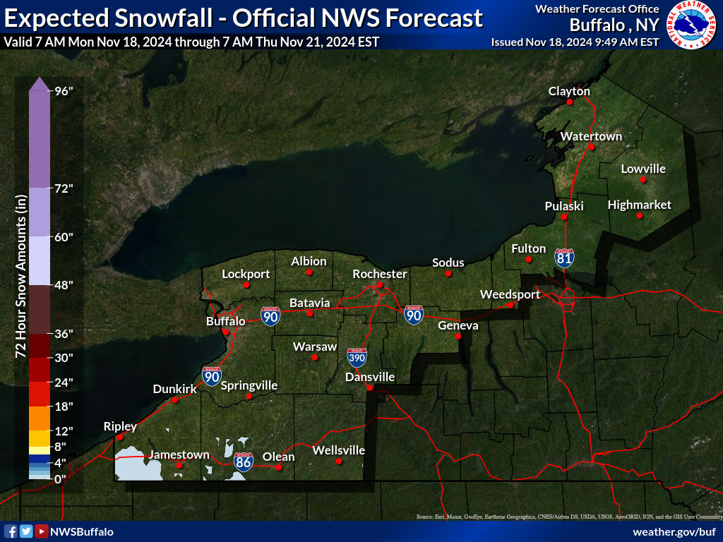
Keep in mind this is from Saturday afternoon through the night Sunday however....
- The snow band will shift and not everywhere on this map (really focusing on WNY here) will be affected at the same time
- It is going to be windy as all hell, though, so there's a chance everywhere on this map may have white out conditions even if it is not currently snowing
- A majority of the people who travel to the game live within that dark red zone
- Orchard Park is right about where the .2" is on the 22.2" mark below Buffalo
- GO BILLS
-
 1
1
-
 1
1
-
Yinzer is that piece of food stuck between your teeth you can only get out with a flosser.
-
 1
1
-
 2
2
-
-
Along with wind direction, the estimated high strength of the wind makes accumulation much more difficult to predict further out.
-
2
-
-
I don’t think the game will get moved but there will likely be local driving bans all over on Sunday. This has me thinking…
What’s the protocol if there is a driving ban in Orchard Park that is enacted Sunday morning?
I can’t recall there ever being a driving ban at the same time as a game.
-
Worth the listen if you're a weather geek.
Don sums it up in the tweet, though - Harsh game conditions a lock
-
-
O/U at 35.5
That's pretty telling
-
1
-
-
Are there Peacock exclusives this playoff beyond Wild Card Weekend?
-
Speaking of ad revenue, how did we all feel about the 5 minute "review" for the 2-inch pass to Kincaid yesterday near the end of the first half?
Gotta get those commercials in, baby!
-
32 minutes ago, Big Turk said:
Uh Oh...latest Forecast Discussion from NWS Buffalo:
".LONG TERM /THURSDAY THROUGH SUNDAY/... ...ANOTHER Powerful Storm to Impact the Region for the Weekend with SIGNIFICANT Lake Snows and HIGH Winds Possible... Mother Nature is loading up another intense storm for the Lower Great Lakes region for the weekend...as there is increasing confidence that a sub 975mb low will track to our west Saturday and Saturday night. This storm would feature a one-two punch with the definite threat for high winds followed by SIGNIFICANT lake snows.
w this system Saturday and SuThere is near 100% consensus among the various guidance packages that the coldest airmass of the season thus far will follonday with H85 temps tumbling to the minus teens to lower 20s C. This in combination with near steady state winds averaging 250-260 could result in very heavy lake snows that would focus on areas just south of Buffalo and Watertown. Keep in mind that we are still nearly a week away from the event...so its just a good thing to keep in the back of your mind. Trying to refine location of bands and to pinpoint snow amounts is not yet possible at this time."
They don't talk use that word Significant, especially in all caps lightly with this. This means we are likely measuring feet of snow by Sunday night. Key question is where? 250-260 favors the Southowns and Hamburg area which is a bullseye for OP.
I'd expect a Lake Snow Watch issued by early Thursday if not late Wednesday. I've seen this setup plenty of times before, pretty much a given if this holds we are getting hit pretty hard.
Was popping by to post this.
If one is planning to buy resale tix today or tomorrow, wait until this storm forecast is out. Those prices going to drop like the snow.
-
1
-
-
17-0
-
It's going to be very windy.
It might be pretty snowy. Will know more by the middle of this week.
-
1
-
-
42 - 10 Bills
-
1
-
-
Vrabel will have the Titans ready
-
Just now, DrDawkinstein said:
And if there was some coaching conspiracy to keep the ball away from him, they wouldnt be force feeding as a RB after they saw the D take him away in the passing game.
I don't think there is a coaching conspiracy to keep the ball away from him.
I also don't think there's an injury conspiracy where he's too banged up to be on the field as often as he used to be.
-
If Diggs was injured he would not have lined up at RB and taken a carry near the goal line last week
IMO
-
3
-
 7
7
-
2
-
-
I think it's moreso Diggs taking himself out of the game than the coaching staff purposely replacing him at pivital spots in the game.
Why is he taking himself out? That's the question that should be asked.
-
7
-
-
Peterman-esque
-
51 minutes ago, TrentEdwardsCheckDownOn4th said:
I don't think I've ever seen a team go for it on the 7 when a FG or extra point would have tied it. I think Dan Campbell wasn't thinking straight after the refs botched the first play.
Maybe.
Everyone knew they were passing, though. If a team has one play, I think the odds of throwing a TD from the 2 are pretty similar to the odds of throwing a TD from the 7. I wasn't that surprised he went for it again.
-
College football is forever done.
This ND and Oregon “Bowl Game” is akin to a preseason NFL game.
It means nothing and half of the best players on each team are sitting out.
-
3
-
-
Just now, stuvian said:
Why does the home team wear white?
Home team's choice to wear dark or light
-
1
-
-
Fine with going for it especially after the missed XP.
-
1 minute ago, Seventeen said:
Don't think we'd see them until the AFCCG if they're locked into the #5 seed.
If they win out, they can only be 5th, 1st, or 2nd.
1st or 2nd only if the Ravens were to also lose out.
-
Njoku is a great TE.
Wild Card Weekend - Wild Card Weather
in The Stadium Wall
Posted
If this holds there will be driving bans throughout the region Saturday evening/Sunday.